


MapTiler Mobile
MapTiler Mobile介绍
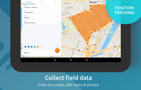
See your GPS position on your own maps. Draw points, polygons and lines on the maps. Collect field data and notes related to a location, attach a photo and fill custom properties.
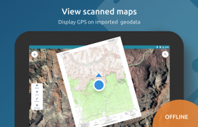
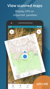
Display offline maps generated with MapTiler (https://www.maptiler.com).
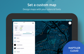
Choose from various basemaps like street and satellite. Preview on a mobile device the map you previously designed with own colors and fonts in MapTiler Cloud.
The app supports GeoJSON and MBTiles formats and data synchronization between multiple devices and desktop computer using cloud. I it easy to share the data with other people and collaborate! Perfect for mobile data collection for GIS and surveys.
Import scanned hiking maps, PDF maps, drone aerial imagery, nautical charts for sailing and navigation with a boat or a yacht, fishing maps, aeronautical charts for flight planning by pilots, parcels and city plans and other opendata from local government. OpenStreetMap vector maps are powered by OpenMapTiles project (the successor of OSM2VectorTiles). Maps can come from existing tile servers with OGC WMTS, TileJSON or XYZ tiles from.
Supported geodata formats by MapTiler: GeoTIFF, TIFF, JPEG, ECW, SID / MrSID, NOAA KAP / BSB, DEM, OziExplorer OZI OZF2 & OZFX3, WebP, JP2, JPEG2000, GeoJP2, Erdas, Grass, Safe, Sentinel2, SRTM, NASA imagery, USGS map sheets, exports from ESRI ArcGIS, ArcSDE, etc.
The GeoJSON can be converted from / to: ESRI ShapeFile (SHP), DXF, DWG, GPX, CSV and KML.
在您自己的地图上查看您的GPS位置。在地图上绘制点,多边形和线条。收集与位置相关的字段数据和注释,附加照片并填充自定义属性。
显示使用MapTiler(https://www.maptiler.com)生成的离线地图。
从街道和卫星等各种底图中选择。在移动设备上预览您之前使用MapTiler Cloud中自己的颜色和字体设计的地图。
该应用程序支持使用云的多个设备和台式计算机之间的GeoJSON和MBTiles格式以及数据同步。我很容易与其他人分享数据并进行协作!适用于GIS和调查的移动数据收集。
导入扫描的远足地图,PDF地图,无人机航拍图像,用船或游艇航行和导航的航海图,钓鱼地图,飞行员飞行计划的航图,地块和城市规划以及当地政府的其他操作数据。 OpenStreetMap矢量地图由OpenMapTiles项目(OSM2VectorTiles的后继者)提供支持。地图可以来自现有的瓷砖服务器,其中包含OGC WMTS,TileJSON或XYZ瓷砖。
MapTiler支持的地理数据格式:GeoTIFF,TIFF,JPEG,ECW,SID / MrSID,NOAA KAP / BSB,DEM,OziExplorer OZI OZF2和OZFX3,WebP,JP2,JPEG2000,GeoJP2,Erdas,Grass,Safe,Sentinel2,SRTM,NASA图像,USGS地图表,ESRI ArcGIS,ArcSDE等的出口。
GeoJSON可以从/转换为:ESRI ShapeFile(SHP),DXF,DWG,GPX,CSV和KML。
MapTiler Mobile - 版本2.0.1
(12-03-2020)MapTiler Mobile - APK信息
APK版本: 2.0.1程序包: com.maptiler.geoeditorMapTiler Mobile的最新版本
其他版本


同类应用


